Introduction: Why This Topic Matters
Maharashtra, India's second-most populous state and largest contributor to the national GDP, faces a paradox of plenty and scarcity. While the Western Ghats (Sahyadri) receive over 3,000 mm of rainfall annually, vast stretches of Marathwada and Vidarbha suffer chronic drought year after year. This uneven distribution of water makes irrigation infrastructure not just an engineering challenge, but a socio-economic and political imperative.
For MPSC, UPSC, and other competitive exam aspirants, the topic of Irrigation Projects in Maharashtra is a recurring and high-weightage subject. This article provides a structured, educator-grade breakdown — covering river basins, major and medium projects, key dams, policy frameworks, and contemporary developments.
Section 1: The Geographical Canvas — River Basin Architecture
Before understanding irrigation projects, one must understand where the water comes from. Maharashtra is drained by six major river basin systems:
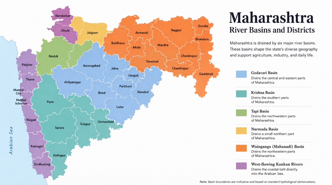
The Western Ghats (Sahyadri Range) act as the master water divide of the state. Rivers flowing east — Godavari, Krishna, Bhima, Tapi — ultimately drain into the Bay of Bengal. Rivers flowing west (Konkan coastal rivers) drain into the Arabian Sea.
| River Basin | Share of Annual Water Availability | Key Feature |
|---|---|---|
| Godavari | ~31% (50,880 Mcum) | Largest basin in the state |
| Krishna | ~21% (34,032 Mcum) | Originates at Mahabaleshwar |
| Tapi (Tapti) | Significant northern belt | Flows west into Arabian Sea |
| Narmada | Smaller share | Touches northern tip |
| Wainganga (Mahanadi) | Vidarbha's lifeline | Eastern Maharashtra |
| West-Flowing (Konkan) | ~43% of surface water | Largely unharnessed |
Educator's Insight: Here lies Maharashtra's core water crisis — 43% of the state's surface water flows through west-flowing rivers into the Arabian Sea, yet these rivers serve a geologically constrained terrain and are difficult to harness. Meanwhile, the four east-flowing basins (Godavari, Krishna, Tapi, Narmada) together cover 92% of cultivable land but share only 57% of the reliable surface yield.
Section 2: Classification of Irrigation Projects
The Maharashtra Water Resources Regulatory Authority (MWRRA) classifies irrigation projects based on their Culturable Command Area (CCA):
| Category | Culturable Command Area (CCA) | Example |
|---|---|---|
| Major Projects | More than 10,000 hectares | Jayakwadi, Koyna, Ujjani |
| Medium Projects | 2,000 – 10,000 hectares | Mula, Nira, various |
| Minor Projects | Less than 2,000 hectares | Kolhapur-type weirs, percolation tanks |
Maharashtra has proposed 25 sub-basins for planning purposes, as documented in the MWRRA map. These sub-basins help in micro-level water allocation, inter-basin transfers, and equitable distribution between regions.
Section 3: The Sub-Basin Framework (MWRRA — 25 Sub-Basins)
The Government of Maharashtra and the MWRRA have defined 25 planning sub-basins to enable systematic water resource management. These are organized under the major river basins as follows:
- Upper Godavari (Upto Paithan Dam) — subdivided into (a) Godavari excluding Mula-Pravara and (b) Mula and Pravara
- Lower Godavari (Downstream of Paithan Dam)
- Purna (including Dudhana)
- Manjra
- Godavari-Swarna
Under Krishna Basin:
6. Upper Krishna (West) — with North-West and West sub-divisions
7. Upper Krishna (East) — Yerala and Agrani
8. Upper Bhima (Upto Ujjani)
9. Remaining Bhima — including Neera and Downstream of Ujjani (with Man)
10. Sina-Bori-Benetura
Under Tapi Basin:
11. Purna (Tapi)
12. Girna
13. Panzra
14. Middle Tapi — Tapi (Satpuda) and Tapi (South)
15. Narmada
Under Wainganga-Mahanadi:
16. Painganga
17. Wardha
18. Middle Wainganga
19. Lower Wainganga — including Wainganga-Pranhita, Inchampalli, Indravati
Konkan Region:
20. North Konkan
21. Middle Konkan
22. Vasishtha
23. South Konkan — Ratnagiri and Sindhudurg
24. Damanganga-Par
25. Terekhol-Tillari
This 25-sub-basin framework is central to the Integrated State Water Plan (ISWP) and helps prevent inter-regional water conflicts — a persistent political flashpoint in Maharashtra.
Section 4: Major Irrigation Projects in Detail
4.1 Jayakwadi Project (Nath Sagar) — The Giant of Marathwada
| Attribute | Details |
|---|---|
| River | Godavari |
| Location | Paithan Taluka, Sambhajinagar (Aurangabad) district |
| Type | Earthen Dam (one of the largest earthen dams in Asia) |
| Height | 41.30 m |
| Reservoir | Nath Sagar (Nathsagar Lake) |
| Storage Capacity | 2,171 million cubic meters |
| Year Completed | 1976 (construction began late 1960s) |
| Primary Purpose | Irrigation (drought-prone Marathwada region) |
| Secondary Purpose | Drinking water, industrial supply, hydropower (~12 MW) |
| Districts Benefited | Sambhajinagar (Aurangabad), Jalna |
Why it matters:
Jayakwadi is Maharashtra's largest dam by storage capacity and the largest irrigation project in the state. Built specifically to combat chronic drought in Marathwada, Nath Sagar reservoir serves as a seasonal lifeline for millions of farmers and urban residents. It is also a bird sanctuary — attracting migratory flamingos and other avifauna, making it a unique confluence of utility and ecology.
4.2 Koyna Dam — The Power Giant of the Western Ghats
{Image Context: Photograph of Koyna Dam showing the rubble-concrete structure on the Koyna River with the Sahyadri mountains in the background and Shivsagar Lake in the foreground}
| Attribute | Details |
|---|---|
| River | Koyna (Tributary of Krishna) |
| Location | Koyna Nagar, Satara district (Western Ghats) |
| Type | Rubble-Concrete Gravity Dam |
| Height | 103.2 m (Tallest dam in Maharashtra by height) |
| Reservoir | Shivaji Sagar (Shivsagar) Lake (~50 km long, 891.78 km² area) |
| Storage Capacity | ~105 TMC / 2,797 million m³ |
| Year Completed | Completed in 1964; expansions continued |
| Primary Purpose | Hydroelectric Power Generation |
| Installed Capacity | 1,920 MW (one of India's largest hydroelectric projects) |
Special Note — Reservoir-Induced Seismicity (RIS):
The Koyna Dam is associated with one of the world's most documented cases of Reservoir-Induced Seismicity (RIS). The filling of Shivaji Sagar Lake has triggered multiple earthquakes in the region since the 1960s, making this a critical case study in geotechnical engineering and dam safety.
4.3 Ujjani Dam (Bhima Dam) — Solapur's Saviour
| Attribute | Details |
|---|---|
| River | Bhima (Tributary of Krishna) |
| Location | Ujjani village, Solapur district |
| Type | Earthfill cum Masonry Gravity Dam |
| Height | 56.4 m (185 ft) |
| Length | 2.534 km |
| Storage Capacity | ~110.9 TMC (largest reservoir in Maharashtra by total capacity) |
| Reservoir | Yashwant Sagar (also called Bhimalwadi Lake) |
| Hydropower | ~12–19 MW (pumped storage) |
| Beneficiary Area | ~500 km² of irrigated land |
Special Feature: The reservoir area near Bhigwan is a designated Ramsar Wetland site, internationally recognized for its flamingo population and biodiversity. This makes Ujjani a uniquely multipurpose project serving agriculture, power, industry, and ecology simultaneously.
4.4 Upper Painganga Project (Isapur Dam) — Vidarbha's Backbone
| Attribute | Details |
|---|---|
| River | Painganga |
| Location | Hingoli-Yavatmal-Nanded corridor |
| Type | Earthfill Dam |
| Purpose | Irrigation for eastern Vidarbha |
| Sub-Basin | Painganga (Sub-Basin No. 8 under MWRRA) |
4.5 Gosikhurd Project — Vidarbha's Irrigation Lifeline
| Attribute | Details |
|---|---|
| River | Wainganga |
| Location | Bhandara district |
| Purpose | Irrigation of Vidarbha (Bhandara, Gondia, Nagpur, Wardha, Yavatmal, Chandrapur) |
| Status | Long under construction; critical national project |
Gosikhurd is a National Project declared under the Accelerated Irrigation Benefits Programme (AIBP). It is one of the most significant and contested projects in Vidarbha, promising to irrigate nearly 2.5 lakh hectares of farmland across six districts. Delays in completion have made it a subject of both political debate and regional aspiration.
4.6 Other Key Projects — Basin-wise Snapshot
Godavari Basin:
- Gangapur Dam (Nashik) — drinking water for Nashik city
- Mula Dam (Nashik) — multi-purpose
- Darna Dam (Nashik) — water supply
- Nilwande Project (Ahmadnagar) — major irrigation on Pravara River
- Bhandardara (Wilson Dam) — oldest reservoir on Pravara river
Krishna Basin:
- Koyna HEP (Satara) — Stages I to VI, generating 1,920 MW
- Warna Project (Kolhapur/Sangli)
- Dudhganga, Radhanagari (Kolhapur)
- Tillari Project (Sindhudurg) — inter-state project with Goa
- Dhom Dam (Satara) — on Krishna River
Bhima Sub-Basin:
- Khadakwasla Dam (Pune) — drinking water for Pune city
- Panshet, Warasgaon, Temghar — Pune's water chain
- Ujjani (Solapur) — as described above
- Sina Kolegaon, Bhima-Sina Link Canal — inter-basin connectivity
Tapi Basin:
- Hatnur Dam (Jalgaon) — on Tapi River
- Girna Dam (Nashik-Jalgaon) — on Girna River
- Khadakpurna (Buldhana)
- Upper Wardha, Bembla, Katepurna (Amravati-Wardha region)
Wainganga Basin (Vidarbha):
- Bawanthadi, Pench HEP — inter-state with Madhya Pradesh
- Itiadoh, Sati, Kathani (Gondia-Bhandara)
Section 5: Inter-Basin Water Transfer — Solving the Distribution Problem
Maharashtra's greatest hydrological challenge is spatial mismatch — water-surplus basins in the west and extreme scarcity in the east (Marathwada and Vidarbha). The government has launched several inter-basin transfer initiatives:
Krishna-Marathwada Link (KM Link)
A proposal to bring approximately 55 TMC of water from the Krishna valley to the Bhima valley. The Maharashtra Irrigation Development Program (MIDP), backed by World Bank funding of ₹4,000 crore, was approved in March 2024. This scheme focuses on diversion of floodwater that would otherwise flow unutilized into the sea.
Integrated State Water Plan (ISWP) — River Interlinking
The Maharashtra government has committed to channelizing 300 TMC of surplus water from west-flowing rivers (Konkan coastal rivers draining into the Arabian Sea) into the Godavari basin to address drought in Marathwada, Vidarbha, and parts of North Maharashtra. This is part of the Integrated State Water Plan linking six major river basins using modern diversion and lift technologies.
Mhaisal Lift Irrigation Scheme (Krishna Koyna LIS)
One of the world's largest lift irrigation schemes, bringing water from the Krishna-Koyna confluence through multiple stages (Stages I–VI) to drought-prone areas of Sangli, Solapur and western Marathwada.
Tembhu Lift Irrigation Scheme
Located in the Krishna basin, Tembhu LIS lifts water from the Krishna river backwaters (created by Almatti Dam, Karnataka) to irrigate areas in Sangli and Satara districts during otherwise lean seasons.
Section 6: Governance Framework
Maharashtra Water Resources Regulatory Authority (MWRRA)
Established under the Maharashtra Water Resources Regulatory Authority Act, 2005, MWRRA is the apex regulatory body for water allocation, pricing, and dispute resolution in the state. It:
- Allocates water entitlements to all sectors (agriculture, drinking, industry)
- Fixes water tariffs
- Resolves inter-district and inter-project water conflicts
- Maintains the 25 sub-basin planning framework
Accelerated Irrigation Benefits Programme (AIBP)
A central government scheme under which several stalled Maharashtra projects — including Gosikhurd and others — received priority funding to accelerate completion.
PMKSY (Pradhan Mantri Krishi Sinchayee Yojana)
The national scheme for expanding irrigated area with the motto "Har Khet Ko Pani, More Crop Per Drop". Maharashtra is one of the largest beneficiaries.
Section 7: Key Statistics at a Glance
| Metric | Data |
|---|---|
| Total large/functional dams in Maharashtra (2023) | 2,333 |
| Largest dam by storage capacity | Jayakwadi (2,171 million m³) |
| Largest dam by height | Koyna (103.2 m) |
| Largest reservoir by total capacity | Ujjani (~3,140 million m³) |
| Largest hydropower capacity | Koyna (1,920 MW) |
| Total MWRRA planning sub-basins | 25 |
| West-flowing rivers' share of surface water | ~43% |
| East-flowing rivers' cultivable land share | ~92% |
| Godavari basin share of state's water | ~31% (50,880 Mcum) |
| Krishna basin share | ~21% (34,032 Mcum) |
Section 8: Challenges and Contemporary Issues
- Regional Inequity: Marathwada and Vidarbha have the largest cultivable land but the most acute water scarcity, creating agrarian distress and farmer suicide crises.
- Siltation: Dams like Ujjani and Jayakwadi have lost significant storage capacity due to sediment accumulation. A new silt-removal policy was announced in 2024–25.
- Incomplete Projects: Several projects sanctioned decades ago remain incomplete — Gosikhurd is a prime example, delayed for over three decades.
- Water Conflict: Inter-district and inter-state disputes (notably with Karnataka over Krishna waters and with Madhya Pradesh over Tapi-Pench waters) remain unresolved.
- Reservoir-Induced Seismicity: The Koyna region continues to be seismically sensitive.
- Underutilization of Konkan Water: 43% of Maharashtra's surface water drains into the Arabian Sea, largely unharnessed due to geological constraints.
- Climate Change Impact: Irregular and intense monsoon patterns are reducing the predictability of dam filling, especially in rain-shadow zones.
Section 9: Sample MCQs for Practice
Which is the largest dam in Maharashtra by storage capacity?
On which river is the Jayakwadi Dam constructed?
How many planning sub-basins has the MWRRA defined for Maharashtra?
The Gosikhurd Project is located on which river?
Which dam in Maharashtra is associated with the phenomenon of Reservoir-Induced Seismicity (RIS)?
What percentage of Maharashtra's surface water flows through west-flowing rivers that drain into the Arabian Sea?
The Ujjani Dam reservoir (Yashwant Sagar/Bhigwan Lake) is recognized under which international environmental convention?
Which scheme carries the motto
Quick Revision: Memory Anchors
| Remember This | Key Fact |
|---|---|
| Jayakwadi = Jumbo storage | Largest by capacity in Maharashtra |
| Koyna = King of height | Tallest dam, 103.2 m, 1,920 MW |
| Ujjani = Ultimate reservoir | Largest total reservoir volume |
| Gosikhurd = Great Vidarbha hope | National project on Wainganga |
| 25 sub-basins | MWRRA planning framework |
| 43% goes west | Konkan rivers, largely unharnessed |
| Nath Sagar | Reservoir of Jayakwadi |
| Shivsagar | Reservoir of Koyna |
Irrigation projects in Maharashtra are not mere engineering structures — they represent decades of political will, socioeconomic aspiration, and ecological negotiation. From the earthen colossus of Jayakwadi guarding drought-prone Marathwada, to the hydroelectric giant Koyna powering western India, to the incomplete promise of Gosikhurd in Vidarbha — each project tells a story of a state wrestling with its most fundamental challenge: getting water to where it is needed most.
For exam aspirants, mastering this topic means understanding not just names and numbers, but the why behind each project — the regional disparities, the policy instruments, and the governance mechanisms that shape Maharashtra's water future.
-
Sources: MWRRA Maharashtra (mwrra.maharashtra.gov.in) | Maharashtra Tourism Department | Water Resources Department, GoM | Academic research on Maharashtra water basins*
-
Last Updated: May 2026 | For MPSC Rajyaseva, UPSC GS Paper 1 & 3, and current affairs preparation*