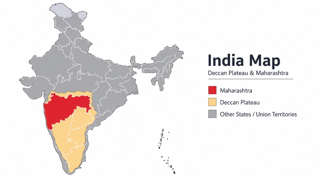
What is the Deccan Plateau? — Let's Build the Foundation First
Before we dive deep, let's think about this with a simple analogy: imagine a gigantic ancient dinner plate tilted slightly from west to east and placed across peninsular India. That is essentially what the Deccan Plateau looks like — a vast, elevated, relatively flat landmass that has shaped the history, economy, culture, and ecology of millions of people for thousands of years.
The word "Deccan" is derived from the Sanskrit word "Dakshina", meaning south. It is one of the oldest and largest plateaus in the world, covering approximately 5 lakh square kilometres of western, central, and southern India. This is not just geography — it is the foundation upon which Maharashtra, Telangana, Karnataka, Andhra Pradesh, and several other states have been built.
Location and Boundaries of the Deccan Plateau
The Deccan Plateau has a roughly triangular shape — broader in the north and narrowing towards the southern tip of the Indian peninsula. Understanding its boundaries is essential for any competitive exam.
| Direction | Boundary Feature |
|---|---|
| North | Vindhya Range and Satpura Range |
| West | Western Ghats (also called Sahyadri) |
| East | Eastern Ghats (merging towards Bay of Bengal) |
| Northwest | Arabian Sea |
| Southeast | Bay of Bengal |
Exam Tip: The plateau slopes from west to east, which is why almost all major rivers of the plateau — Godavari, Krishna, Kaveri — flow eastward into the Bay of Bengal.
How Was the Deccan Plateau Formed? — The Volcanic Story
This is one of the most fascinating chapters in Earth's geological history, and one that directly explains the unique character of Maharashtra's landscape.
Around 65 million years ago, when dinosaurs were disappearing from the Earth, something dramatic was happening beneath the Indian subcontinent. As the Indian Plate moved northward and collided with the Eurasian Plate, massive cracks formed in the Earth's crust. Through these cracks, enormous quantities of basaltic lava erupted repeatedly over millions of years.
These lava flows, layer upon layer, created what geologists call the "Deccan Traps" — the word "Trap" coming from the Swedish word trappa meaning "staircase", because the solidified lava created a characteristic step-like (trap) landscape.
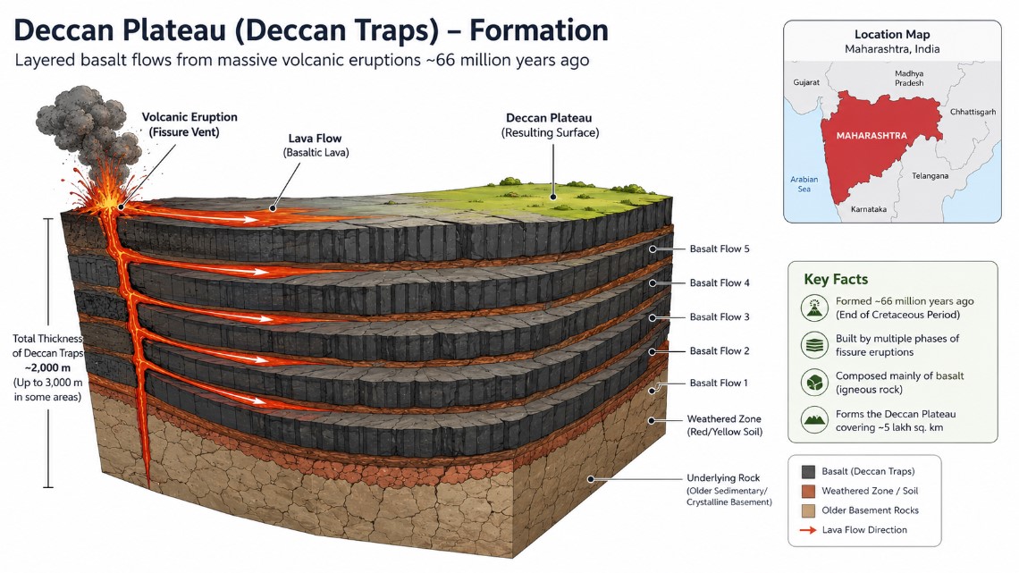
Key facts about Deccan Traps:
- One of the largest volcanic features on Earth
- The basalt layers can be 2,000 metres thick in some parts of Maharashtra
- The trap landscape is particularly prominent in Nashik, Pune, Aurangabad, and Nanded districts of Maharashtra
- This volcanic origin is responsible for the extremely fertile black cotton soil (regur) found across Maharashtra
Sub-Plateaus of the Deccan: Where Does Maharashtra Fit?
The Deccan Plateau is not a single uniform region. River erosion over millions of years has carved it into three major sub-plateaus, each with distinct characteristics.
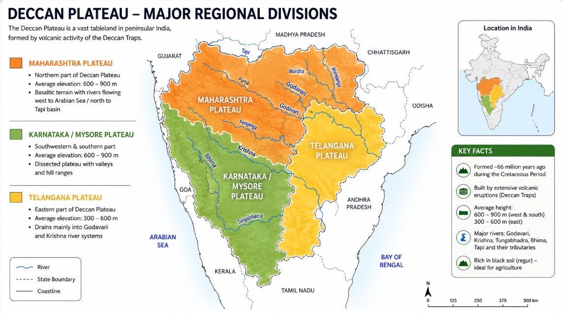
1. Maharashtra Plateau — The Heart of the Deccan
The Maharashtra Plateau forms the northern section of the Deccan Plateau and is arguably the most geographically significant sub-region for students preparing for Maharashtra state exams (MPSC, TET, State PSC).
Key Physical Characteristics:
- Predominantly composed of basalt rock formed from ancient Deccan Trap lava flows
- The surface has a rolling plain appearance due to centuries of weathering and erosion
- The characteristic step-like trap landscape is clearly visible in many parts of Marathwada and Vidarbha
- Average elevation ranges from 500 to 800 metres above sea level
Rivers of Maharashtra Plateau:
The plateau is drained by three major river systems, all ultimately flowing eastward:
| River | Origin | Key Districts Covered |
|---|---|---|
| Godavari | Trimbakeshwar, Nashik | Nashik, Aurangabad, Nanded, Yavatmal |
| Bhima | Bhimashankar (Western Ghats) | Pune, Solapur, Osmanabad |
| Krishna | Mahabaleshwar | Sangli, Satara, Kolhapur |
Important: The Godavari is the longest river of the Deccan Plateau and is often called the "Dakshin Ganga" (Ganges of the South). Its basin covers more than half of Maharashtra.
Soil of Maharashtra Plateau:
The entire Maharashtra Plateau is blanketed with black cotton soil, locally called "regur". This is one of the most fertile and economically valuable soils in India.
Why is Black Soil special?
- Formed from the weathering of basaltic lava rocks of the Deccan Traps
- Has high clay content — swells when wet, shrinks and cracks when dry
- Retains moisture for a long time — ideal for dry farming (rainfed agriculture)
- Rich in calcium carbonate, magnesium, potash, and lime
- Naturally suited for growing cotton — which is why Maharashtra is India's top cotton-producing state
2. Karnataka Plateau (Mysore Plateau) — South of Maharashtra
Located south of the Maharashtra Plateau, the Karnataka Plateau has a different geological character. While Maharashtra's plateau is dominated by basalt, Karnataka's plateau is largely composed of older Archaean crystalline rocks (granites and gneisses).
Two distinct zones of Karnataka Plateau:
a) Malnad (Hill Country)
- "Malnad" means hill country in Kannada
- Located along the Western Ghats border
- Has high hills, deep valleys, and dense forests
- Receives very heavy rainfall (over 2,000 mm annually)
- Rich in biodiversity — part of the Western Ghats UNESCO World Heritage site
b) Maidan (Plain Region)
- The interior plateau with low granite hills
- Receives moderate to low rainfall
- More suitable for agriculture and human settlement
- The highest point is Mulangiri Peak in Baba Budan Hills (1,925 m)
- Gradually merges with the Nilgiri Hills in the south
3. Telangana Plateau — The Eastern Section
The Telangana Plateau forms the eastern portion of the Deccan region and has its own distinctive geological signature.
- Composed primarily of very ancient Archaean gneisses (among the oldest rocks in India)
- Average elevation: 500–600 metres
- The southern portion is slightly higher than the northern section
- Drained by major rivers: Godavari, Krishna, and Penneru
Two physical divisions:
- Ghats: Upland and hilly areas with uneven terrain
- Peneplains: Broad, flat plains formed after long cycles of erosion — representing the final stage of landscape leveling
Climate of the Deccan Plateau
The climate of the Deccan Plateau is not uniform — it varies significantly with altitude and distance from the coasts.
| Zone | Climate Type | Rainfall | Temperature |
|---|---|---|---|
| Lower elevations (Marathwada, Vidarbha) | Hot tropical semi-arid | 500–750 mm | 40°C+ in summer |
| Higher elevations (Western Ghats fringe) | Mild subtropical | 1,500–3,000 mm | Moderate |
| Interior Maharashtra (Deccan proper) | Semi-arid continental | 500–700 mm | Extreme summer heat |
Important for Maharashtra exams: The rain shadow effect of the Western Ghats makes interior Maharashtra (Marathwada, parts of Vidarbha) a chronically drought-prone region — a major socio-economic issue in the state.
Agriculture on the Maharashtra Plateau — Crops and Economy
Maharashtra's agricultural landscape is deeply shaped by its geology and climate. The black soil of the Maharashtra Plateau supports a diverse cropping system.
Major crops of Maharashtra Plateau:
| Crop | Region | Soil Used |
|---|---|---|
| Cotton | Vidarbha, Marathwada | Black cotton soil (regur) |
| Sugarcane | Western Maharashtra (Pune, Solapur, Sangli) | Alluvial valley soils near rivers |
| Soybean | Marathwada, Vidarbha | Black soil |
| Jowar (Sorghum) | Marathwada, Solapur | Black and red soil |
| Bajra (Pearl Millet) | Nashik, Ahmednagar | Light black/sandy soil |
| Oranges | Vidarbha (Nagpur) | Well-drained red-black mix |
| Grapes | Nashik district | Well-drained volcanic soil |
Key Fact: Maharashtra is India's No. 1 producer of sugarcane and cotton in terms of economic value. The Deccan black soil is the primary reason for this agricultural dominance.
Mineral Resources of the Deccan Plateau in Maharashtra
The volcanic and metamorphic geology of the Deccan Plateau has gifted Maharashtra with significant mineral wealth, which directly supports its industrial economy.
Important minerals found in Maharashtra and the broader Deccan Plateau:
- Iron Ore — Found in Chandrapur, Gadchiroli districts
- Coal — Chandrapur (one of India's major coalfields) and Yavatmal
- Manganese — Nagpur and Bhandara districts (Maharashtra is among top producers)
- Bauxite — Found in parts of the Western Ghats fringe in Maharashtra
- Limestone — Yavatmal, Chandrapur — used in cement industry
- Silica Sand — Used in glassmaking industries
MPSC Exam Tip: Chandrapur district in Vidarbha is known both as a major coal-producing region and for having the Chandrapur Thermal Power Plant — one of Maharashtra's largest power generation facilities.
Flora and Fauna of the Deccan Plateau
The ecological diversity of the Deccan Plateau reflects its varied terrain, soil types, and rainfall patterns.
Vegetation Types:
- Tropical dry deciduous forests — dominant across interior Maharashtra (Marathwada, Vidarbha)
- Thorn/scrub forests — in low-rainfall areas of Marathwada and Solapur
- Moist deciduous forests — in the foothills of Western Ghats (Sahyadri)
- Semi-evergreen forests — in high-rainfall zones along the Sahyadri
Important Wildlife Sanctuaries in Maharashtra's Deccan Region:
| Sanctuary/Park | Location | Notable Wildlife |
|---|---|---|
| Tadoba-Andhari Tiger Reserve | Chandrapur | Tigers, leopards, gaur |
| Melghat Tiger Reserve | Amravati | Tigers, wild dogs |
| Bhimashankar Wildlife Sanctuary | Pune | Indian giant squirrel (State Animal of Maharashtra) |
| Pench National Park | Nagpur | Tigers, wolves, leopards |
People, Culture, and Heritage of Maharashtra Plateau
The Maharashtra Plateau is not just a physical landscape — it is a living cultural space with thousands of years of civilizational history.
Languages Spoken:
- Marathi — the official and dominant language of Maharashtra
- Hindi — widely spoken in urban centres
- Urdu — spoken significantly in Marathwada (Aurangabad, Nanded, Latur)
- Telugu, Kannada — spoken in border regions
Major Religions: Hinduism (majority), Islam, Buddhism (significant, especially among Dalit communities following Dr. B.R. Ambedkar's conversion movement), Christianity, Jainism
Tribal Communities of Maharashtra's Deccan Region:
- Gond — Gadchiroli, Chandrapur
- Bhil — Dhule, Nandurbar
- Kolam, Madia, Halba — Gadchiroli and Vidarbha
Historical & UNESCO Sites in Maharashtra Plateau:
- Ajanta Caves (Aurangabad) — Buddhist rock-cut cave monastery, UNESCO World Heritage Site
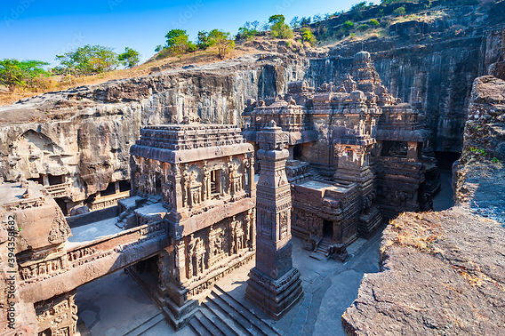
- Ellora Caves (Aurangabad) — Multi-religious rock-cut temples (Hindu, Buddhist, Jain), UNESCO World Heritage Site
- Bibi Ka Maqbara (Aurangabad) — 17th century Mughal-era monument, called "Mini Taj Mahal"
- Daulatabad Fort (Aurangabad) — 12th century hilltop fortress
Economic Importance of the Maharashtra Plateau
Understanding why the Maharashtra Plateau matters economically connects geography to governance — a key theme in UPSC and MPSC exams.
- Agriculture: Cotton, sugarcane, soybean — drives rural livelihoods for crores of Maharashtra's population
- Industry: The Deccan's mineral wealth (coal, manganese) supports Maharashtra's steel, cement, and power sectors
- Irrigation Projects: Major dams on the Godavari, Bhima, and Krishna provide water to drought-prone Marathwada and Vidarbha
- Jayakwadi Dam (Godavari) — largest earthen dam in Asia, located in Aurangabad
- Koyna Dam — on the Krishna tributary, major hydroelectric power source
- Manufacturing Hubs: Pune (automobile capital of India), Nashik (wine and automotive industry), Nagpur (logistics hub — "Zero Mile Centre" of India)
Quick Reference Summary Table
| Feature | Details |
|---|---|
| Total area of Deccan Plateau | ~5 lakh sq. km |
| Maharashtra Plateau location | Northern Deccan |
| Rock type | Basalt (Deccan Traps) |
| Average elevation | 500–800 m above sea level |
| Major rivers | Godavari, Bhima, Krishna |
| Dominant soil | Black cotton soil (Regur) |
| Major crops | Cotton, sugarcane, soybean, jowar |
| Key minerals | Coal, manganese, iron ore, limestone |
| Slope direction | West to East |
| River flow direction | Eastward into Bay of Bengal |
| Formation age | ~65 million years ago (Cretaceous period) |
| Geological origin | Volcanic — Deccan Traps |
Practice MCQs — Test Your Knowledge
Key Takeaways — What Every Aspirant Must Remember
- Deccan = Dakshina = South — The plateau covers ~5 lakh sq. km of peninsular India
- Maharashtra Plateau = Basalt + Black Soil + Eastward-flowing rivers — This triangle is the core of Maharashtra geography
- Deccan Traps = 65 million years old — Volcanic origin makes Maharashtra's soil uniquely fertile
- Rivers slope east — Godavari, Bhima, Krishna all flow from Western Ghats to Bay of Bengal
- Godavari = Dakshin Ganga — Longest river of Deccan, originates in Nashik
- Black soil = Cotton = Maharashtra's agricultural identity — Direct connection between geology and economy
- Chandrapur = Coal + Power | Nagpur & Bhandara = Manganese — Know the mineral map
- Jayakwadi Dam (Godavari) and Koyna Dam (Krishna) — Maharashtra's key irrigation and power projects
- Ajanta and Ellora Caves — UNESCO World Heritage Sites in Aurangabad, symbol of Maharashtra's cultural depth
- Drought in Marathwada and Vidarbha — Rain shadow + Black soil's cracking = chronic water stress
Article prepared for academic and competitive examination purposes. All geographic and factual data is based on standard sources including Maharashtra State Geography textbooks, NCERT physical geography, and Vajiram & Ravi current affairs reference material.